Showing posts with label Adirondack Paddling 2013. Show all posts
Showing posts with label Adirondack Paddling 2013. Show all posts
Monday, October 21, 2013
Paddling Floodwood to Polliwog
Today we led one of our favorite paddles, from Floodwood Pond to Polliwog, where we had spotted a car.

Monday, October 14, 2013
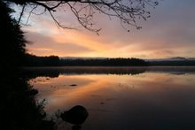
Neither Rain, Nor Snow ............
Well, at least it wasn't snowing. About 20 of us braved the rain today and paddled the Bog River from the lower dam into Hitchins Pond for our traditional Columbus Day picnic. That is, most of us paddled. There were a few hikers and one intrepid bicyclist.


Friday, October 11, 2013
Paddling the Essex Chain of Lakes
We were so pleased when Jim and Cindy invited us to go along on an explore of the newly opened Essex Chain of Lakes. The state recently took over the land and opened it to the public on October 1st. There were already 3 full pages of sign-ins when we got there just 11 days after opening and a ranger we met said there had been a regular parade of folks driving in to paddle.
To get there, drive into Newcomb on 28N and turn right onto Pine Tree Road. Then turn right onto Goodnow Flow Road and follow it down to the flow. Make a right onto Woody's Road and follow the signs to Deer Pond Access. The drive from 28N is about 10 miles. Goodnow Flow Road is paved as is part of Woody's Road but the last several miles of the drive are reminiscent of the rocky road to Lake Lila. I don't recommend doing Lila and the Essex Chain the same week, as we did. It was a bit too much driving on rough roads.
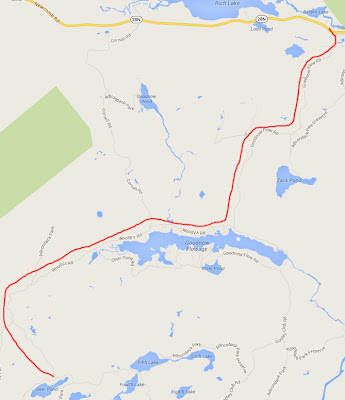 Once you get to the parking lot, you still have 3/4 of a mile to go to get onto Third Lake. The red lines on the following map mark the carries. It is 1/4 mile from the car to Deer Pond, and another 1/2 mile from Deer Pond to Third Lake. Fortunately, most of the carrying is on dirt roads. But the immediate access to the lakes is steep and the put-ins are single file.
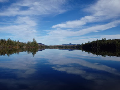
 After all the work to get there, you'll want to spend the day, and it is definitely worth it.
It was cloudy when we started out but as in the last few days, there was absolutely no wind. This was our first view of Third Lake.
 We headed up Third Lake and down the creek toward Fourth.

 We were surprised to find a nice picnic table for lunch on the northwest shore of Fourth Lake.

 Then we proceeded up the lake toward the culvert into Fifth Lake.
 Then onto Fifth Lake and the channel into Sixth. The channel is full of mud islands but we managed to maneuver around them. I was so busy navigating I didn't take any photos in the channel.

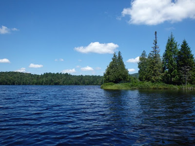
 Then onto Sixth Lake, or is it Seventh? Different maps call it different things. On the map above it is called Sixth.
 Then we retraced our route and continued down Third Lake into Second and the end of the line. This impressive 3-4 feet high beaver dam at the end of Second Lake, toward First, is what holds in enough water to allow you to paddle among the lakes. We can't imagine what the area would be like without it.

We didn't have time to walk down to First Lake, though it is possible to carry your boat around and paddle First Lake as well. We'll have to do that next time. Instead, we headed back through Second Lake

and back into Third under blue skies for a total paddling distance of about 8 miles.
To get there, drive into Newcomb on 28N and turn right onto Pine Tree Road. Then turn right onto Goodnow Flow Road and follow it down to the flow. Make a right onto Woody's Road and follow the signs to Deer Pond Access. The drive from 28N is about 10 miles. Goodnow Flow Road is paved as is part of Woody's Road but the last several miles of the drive are reminiscent of the rocky road to Lake Lila. I don't recommend doing Lila and the Essex Chain the same week, as we did. It was a bit too much driving on rough roads.


It was cloudy when we started out but as in the last few days, there was absolutely no wind. This was our first view of Third Lake.


We didn't have time to walk down to First Lake, though it is possible to carry your boat around and paddle First Lake as well. We'll have to do that next time. Instead, we headed back through Second Lake

and back into Third under blue skies for a total paddling distance of about 8 miles.

Wednesday, October 9, 2013
Paddling Lake Lila
We had a wonderful paddle today. We drove the ~6 mile rough road into the parking lot for Lake Lila and carried the boats 1/3 mile to the shore. But all the effort was really worth it. It was a gorgeous fall day without a breath of wind. This is the view from the shore before we started out.
 The paddlers.
 The view from our lunch stop.
 Moose tracks - we stopped at one of the beaches where a moose had walked by sometime in the last couple of days. My booted foot gives an idea of the size of the track.


Monday, September 23, 2013
An Aborted Paddle - and Its Replacement
Today we were supposed to put our boats into Raquette Lake, paddle the Marion River, Utowana, Eagle and Blue Mountain lakes. Then, after hanging out on the beach for a while, have dinner at Hemlock Hall. That plan was changed the minute we saw the white caps on Blue Mountain Lake. The temps in the low 40's didn't help. So some folks went to the Adirondack Museum for a while. But a group of us still wanted to paddle somewhere, so we put in off Route 28 and paddled up the South Inlet that flows into Raquette Lake. We paddled up to the pretty rapids
 and had lunch in a nice protected spot. Then paddled back to the cars for a round trip distance of just over 4 miles. It is a paddle I've wanted to do, but couldn't see driving all the way there for such a short one. So this worked out nicely. Then we hung out with friends in Indian Lake, finally ending up for dinner at Hemlock Hall.

Monday, September 9, 2013
Paddling the Jessup River
Today's paddle was on the Jessup River south of Indian Lake. We put in at the bridge and headed downstream where we had to go over several large beaver dams.

We went as far as we could, only about a mile, until there were too many rocks in the way and then had lunch at the carry. Then we headed back upstream and went on past the bridge, expecting even more beaver dams. But there were fewer than the other direction so we had a nice paddle until finally stopping at a dam. The whole paddle was just 5.4 miles, but we were tired from all the dragging over dams. Next time, we should head upstream from the start.

We went as far as we could, only about a mile, until there were too many rocks in the way and then had lunch at the carry. Then we headed back upstream and went on past the bridge, expecting even more beaver dams. But there were fewer than the other direction so we had a nice paddle until finally stopping at a dam. The whole paddle was just 5.4 miles, but we were tired from all the dragging over dams. Next time, we should head upstream from the start.
Friday, September 6, 2013
Paddling Massawepie Lake
We finally got on Massawepie today. It is closed all summer because of the scout camp. And once September rolls around, we usually have lots of other paddles we want to do. But it is close-by and we didn't want a long drive today. So we had a nice 5.5 mile paddle around the perimeter. The weather was gorgeous, though fairly windy out on the main part of the lake. But there were some sheltered areas.


There were several frogs where I took my boat out and one stuck around to get his picture taken.

Wednesday, September 4, 2013
Paddling Lake Kushaqua
Ten of us paddled Lake Kushaqua today. It was fairly windy but much of the lake was protected from the wind by the surrounding hills. We paddled the circumference of the lake, for a total of just 5 miles, but it was good to get out on the water.
Monday, September 2, 2013
Paddling Raquette Flow
We had a great Labor Day. We invited our paddling friends over to paddle the Flow and then join us for food, most of which we brought in from a new restaurant in town. The weather was not predicted to be good, but 10 of us braved the weather report and had a very nice paddle. We even were able to eat out on the deck before the rains finally came later in the evening. We managed to fit 21 people into the house and a dozen cars in the driveway. Everyone said they had a good time.
Wednesday, August 21, 2013
Paddling Rainbow Lake
Today a group of us paddled 8.5 miles on and around Rainbow Lake. Another beautiful day.


Monday, August 19, 2013
Paddling the Six Carries Route
Today's group paddle was in the St Regis Canoe Area where we did 6 of the 7 carries and paddled the following ponds and lakes: Little Clear, St Regis, Green, Little Long, Bear, Bog, Upper St Regis, Spitfire, Lower St Regis. It was a beautiful day and the winds weren't too bad.
 And of course we did the requisite picnic at a campsite along the way.


Monday, August 12, 2013
Paddling Little Tupper
This week's Monday paddle was the 13 mile round-trip down Little Tupper Lake into Rock Pond. This is the neat island marking the entrance to the creek.
 The water is so high that beaver dams weren't much of a problem. We did have to pull over one in the creek on the way to Rock Pond, but it was nothing like the first few times we were there when the dams were a couple of feet high and we never found the portage. The pond was bigger than we remembered and was a nice destination.
 Paddling back down the creek this great blue heron accompanied us part of the way.


Monday, July 29, 2013
Paddling the Lower Osgood
A group of us put into the Lower Osgood River off Route 30 and paddled down to Meacham Lake where the cars were waiting. This was the first I had seen cardinal flowers blooming this year. The current was fast enough that I didn't try to steady the boat enough to get a picture. But I did get this photo of new cones on a tamarack tree at the beach where we stopped for lunch.
 And this one of the usual flotilla.


Thursday, July 25, 2013

Monday, July 15, 2013
Paddling Hoel, Turtle, Slang Ponds
Today I paddled with a group of friends, putting in at the private landing on Hoel Pond, carrying over the railroad tracks into Turtle Pond, paddling into Slang, and carrying into Long Pond. The carry was very muddy from all the rain we have had. Though the weather was nice, but a bit hot, there was quite a headwind going out, so we didn't explore much of Long Pond. We stopped at campsite 10 for lunch, then headed back to our friends' camp on Hoel Pond for dessert and a nice visit.
I have my new waterproof Olympus camera, so I took several photos to try it out.

There was a loon with a chick that I managed to photograph.

I have my new waterproof Olympus camera, so I took several photos to try it out.


There was a loon with a chick that I managed to photograph.

Friday, July 12, 2013
Paddling Bridge Brook Pond
It was a beautiful day, finally, so the two of us put in at Rock Island Bay on Tupper Lake and paddled across to the carry to Bridge Brook Pond. We took the carry and paddled around the pond for a while. Since the water is so high, we got farther than we have in the past. And we saw another beaver and lots of frogs. We thought we would have the lake to ourselves, but there was a family camping there. We paddled a total of about 8.5 miles, plus 1/2 mile of carrying, so we were too tired to paddle all the way to the end of the lake to see Bog River Falls. So we drove down there instead, and boy is there a lot of water coming over.


Tuesday, July 9, 2013
Paddling Browns Tract
The weather finally cleared enough today for us to do a new paddle. We put in on Raquette Lake at the town launch in the upper right of the photo and paddled up Browns Tract. It was a beautiful paddle with acres of white water lilies and lots of rose pagonia orchids. I don't have my new waterproof camera yet, or I would have taken photos. We lunched on the boardwalk at the end of the carry from Eighth Lake (the white line you can barely see coming out of the woods on the bottom left of the picture) and then retraced our steps. The total paddle was just 5.5 miles.


Monday, June 24, 2013
Paddling to Weller Pond
This morning a group of us dared the weather and paddled South Creek to Middle Saranac to Little Weller and Weller Ponds.
We were happy to see a pair of eagles on Ship Island; we never saw them last year and were afraid they were gone for good. Also, the iris

and swamp laurel

are blooming.
We were lunching on Tic Island when the thunder started rumbling. Some of us made a hasty retreat, worried as much about winds on Middle Saranac as the lightning. The storm never hit us, but it had obviously rained buckets just before we got to Tupper Lake. It has been very hot and humid so afternoon thunderstorms have become the norm.
Thursday, June 20, 2013
Paddling the Raquette River from the Crusher to Moody
Today a group of us paddled the 8.5 miles from the Crusher put-in on the Raquette River to the state boat launch at Moody on Tupper Lake. It was a fast downstream paddle so not nearly as strenuous as yesterday's paddle. The weather was beautiful.
Wednesday, June 19, 2013
A New Paddle
The water is still very high, so today we tried a paddle we hadn't done before. We drove just a few miles west on Route 3 and stopped at the parking area next to Dead Creek. We put in there and went upstream. We thought we would be stopped by beaver dams, but the few we encountered could be "skooched" over. The water was very fast and the turns very tight. So after paddling upstream for 3 miles, we called it quits due to fatigue instead of beavers. We are paddling again tomorrow and didn't want to completely exhaust ourselves.
 It is very hard to see on this map, but Route 3 is on the upper right and we paddled up the winding stream almost to the lower left. It goes on and on from there. Maybe we will go farther next time, though there are few places one can get out of the boat and I'm sure it can only be done during high water. At least now we can say we explored at least part of Dead Creek.

Subscribe to:
Posts (Atom)