Showing posts with label Adirondack Hiking. Show all posts
Showing posts with label Adirondack Hiking. Show all posts
Saturday, October 2, 2010
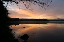
Hiking to Moose Pond
After a couple of days being stuck inside by very rainy weather, we decided to go out for a hike, even though it was still quite gray. We have been wanting to check out the hike to Moose Pond from Route 3 and it was very pleasant. It is less than 2 miles each way and relatively flat. As people have told us, it is a nice cross-country ski route. Here is a view of Whiteface from the shoreside rock where the path ends.
Thursday, October 1, 2009
Hiking Stone Valley
9 of us (8 women and W) hiked down the east side of Stone Valley today. The 3-mile hike to cars spotted at the other end was a perfect length. While the weather was gray, it didn't actually rain until we were at our post-hike lunch at the Hideaway Cafe just outside of Colton on Route 68. A very popular place with good food. There wasn't a lot of water in the river, but it was still picturesque. And there were LOTS of fungi around. Including this beauty.
And there were LOTS of fungi around. Including this beauty.
Wednesday, September 30, 2009
Hike to Devil's Pulpit
It's been raining for days so we went on a hike today even though it was still raining and SNOWING. Just wet stuff in the air that didn't stick to anything, but still... It isn't even October yet.
We bushwacked from Route 3 to the large rock called Devil's Pulpit overlooking the Saranac River between the Upper Locks and Lower Saranac Lake. There is a little dot in the river in this photo that is a lone kayaker. Given all the rain, we saw some neat fungi.

Given all the rain, we saw some neat fungi.Sunday, September 20, 2009
Wilmington Notch Falls
It was a beautiful day today and it was about time for some more apples, so I used that as an excuse to drive to Pray's farm market in Keeseville and stopped at the falls on the Ausable River at Wilmington Notch on the way back home. I love the "rocks and roots" at the falls overlook. And the falls were as great as ever.
 There was a lot less water than there is earlier in the season, but that means there were more rocks to scramble on and it was easier to ford the little streams flowing into the river as I made my way upstream.
Note: I've since been told that Banker's Orchards on Route 3 west of Plattsburgh is a good place to get apples. I'll probably try them next time.
And the falls were as great as ever.There was a lot less water than there is earlier in the season, but that means there were more rocks to scramble on and it was easier to ford the little streams flowing into the river as I made my way upstream.Note: I've since been told that Banker's Orchards on Route 3 west of Plattsburgh is a good place to get apples. I'll probably try them next time.
Friday, January 2, 2009
Hike to the Bog River
We finally managed to hike to the Bog River from the trailhead on Route 421, not far from its intersection with Route 30. We just wore our snow boots, but probably should have had snowshoes. There was a lot more snow that we have at home. Despite the cold temperatures (mid-twenties; it hasn't been above freezing for days) there were running streams crossing the path. It is definitely a path one walks only when the ground is frozen or it is a very dry summer. W took this photo with his cell phone.
Saturday, November 22, 2008
Snowy River
We walked on the trails on and near the Wild Center property for about an hour this afternoon. It was gray and snow showery the whole time, with several inches of snow underfoot from the fairly constant snow showers since we've been here. This is a view of the Raquette River from one of the overlooks.
Thursday, November 20, 2008
Deer Hunting Season....
... is not a good time for hiking. We're having the same problem we had the last time we were here in late November - finding someplace to hike that is away from the hunters. Today we headed for the trail to the Bog River that takes off from Rte 421 not far from its intersection with Rte 30. But there was a pickup parked at the trailhead, a sure sign of a hunter down the trail. So we drove a little farther and explored the area around Bog River Falls instead. The water was very high.
We found the place one can put a boat in to go around this spot and head upstream. You can only go a couple miles until the next rapid, but it is supposed to be a beautiful trip. We'll try that next summer.
We found the place one can put a boat in to go around this spot and head upstream. You can only go a couple miles until the next rapid, but it is supposed to be a beautiful trip. We'll try that next summer.
Sunday, September 21, 2008
ADK Fall Outing
We spent the weekend at the Adirondack Mountain Club fall outing, headquartered at the Wilmington KOA campground, where we stayed in a nice cabin. A group of about 100 ADK members from all over the state took part in organized hikes, paddles, bike rides throughout the weekend. On Friday we took a short paddle on Lake Everest, a wide section of the West Branch of the Ausable River near Wilmington. The paddle included maneuvering over 2 beaver dams which added to the excitement. We saw this osprey and the remains of his/her nest.  Most of the nest plus some of its supporting branches were destroyed by the remnants of hurricane Ike that came through recently.
Most of the nest plus some of its supporting branches were destroyed by the remnants of hurricane Ike that came through recently.On Saturday we paddled the Ausable River from the bridge on Route 9 out to Lake Champlain via the northern route shown on the map. The lake was very windy, so we paddled into a quiet side channel and walked out to the lake.
 Someday when the wind isn't so strong we want to go back and paddle out one branch of the river and in the other, paddling the section of the lake in between.
The lake was very windy, so we paddled into a quiet side channel and walked out to the lake. Someday when the wind isn't so strong we want to go back and paddle out one branch of the river and in the other, paddling the section of the lake in between.On Sunday the weather wasn't nearly as nice, with low misty clouds. But we decided to go on a hike anyway. We climbed Cobble Hill, behind Northwoods School in Lake Placid. We are told there are usually nice views of Mirror Lake and Lake Placid from the top, but we saw very little. There is a nice rock scramble to get to the top that J would like. We'll have to take him there sometime, if we can find the path again. The entrance and exit (via a walk along Echo Lake) are off a private drive.
Tuesday, August 19, 2008
Bloomingdale Bog
Today we hiked on the railroad bed through the Bloomingdale Bog, starting at the Route 86 end. It was a nice walk, including lots of yummy blueberries within reach of the path.
Thursday, July 17, 2008
Orchids at the VIC
We finally made it to Paul Smith's Visitor Interpretive Center, otherwise known as the VIC. Someone told me that the Boreal Life Trail was the place to find orchids and we weren't disappointed. There were lots of White Fringed Orchis (Habenaria blephariglottis), Rose Pogonia (Pogonia ophioglossoides),
 and Calopogon (Calopogon pulchellus).
 We spent so much time on that trail all we had time for besides it was the short Barnum Brook Trail which has nice bridges over the stream. We saw some toads and this snake.
 We'll have to go back sometime and explore the other trails.
Rose Pogonia (Pogonia ophioglossoides),and Calopogon (Calopogon pulchellus).We spent so much time on that trail all we had time for besides it was the short Barnum Brook Trail which has nice bridges over the stream. We saw some toads and this snake.We'll have to go back sometime and explore the other trails.On the way home we saw this snapping turtle about to cross the road. We herded it across to the other side out of the traffic and took its picture.
Sunday, June 15, 2008
Hiking the Stone Valley Trail
We had a great hike today along part of the Stone Valley Trail along the Raquette River. We picked up the trail off Main St. in Colton and walked down the east side of the river. Last Tuesday's storm caused major destruction in the area. The beginning of the trail was blocked with several massive trees and further along the trail we encountered many areas where we had to bushwack around the blowdown. We finally stopped about a mile in when we got tired of dodging downed trees. But that mile was spectacular with beautiful views of the river and falls.
 Thanks to W for letting me use his laptop connected to the cell network to publish this post. Our satellite connectivity is flaky at best. A technician has been called.

 Thanks to W for letting me use his laptop connected to the cell network to publish this post. Our satellite connectivity is flaky at best. A technician has been called.
Friday, June 6, 2008
Hike up Silver Lake Mountain
Today we hiked with ADK up Silver Lake Mountain and then to Silver Lake Bog. The hike up the mountain was timed to coincide with the blooming of the lady slipper orchids, which we found in abundance.


We also found some neat critters.
Friday, October 5, 2007
Hike near Tupper Lake
Today's temperatures approached 80 degrees, so I chose a woodsy, shaded trail for my hike today. I parked along Route 30 between the two parking areas on the southern end of Tupper Lake (the lake, that is, not the town) where I had seen what I thought was the trailhead. I was right. It is not marked but obviously used to be a road. I had hoped to get over to the beach we found when we were kayaking in the area, but it would have taken some steep bushwacking since the trail remains up on the ridge. It ends at what must have been a house site and is now a campsite overlooking the lake. The trail would make good x-country skiing or snowshoeing, though there would have be enough snow to sift through the overhanging trees. And if there where that much snow, there might not be a place to park the car. But it might be worth checking out this winter.
Friday, August 17, 2007
Hike to Moody Falls
Today was one of those spectacular clear days with low humidity that we love here. As part of our ongoing search for the course of the Raquette River, we hiked the short canoe carry from Route 56 to Moody Falls. The carry is quite steep - not one we would attempt with a boat. Plus, it is only .8 miles until you hit Jamestown Falls so hardy worth the paddle. The carry ends downstream of the falls, so we followed a narrow trail along the river to the falls. 

Tuesday, August 14, 2007
Hike to Jamestown Falls
Today we hiked again to Jamestown Falls from the woods road off Route 56. J enjoyed climbing on the rocks and found a green frog in one of the pools.
Monday, August 13, 2007

Friday, July 13, 2007
Hike to Trombley Landing
We needed a close and relatively short walk this morning before the rains came again. We decided to hike down to Trombley Landing
 on the Raquette River.
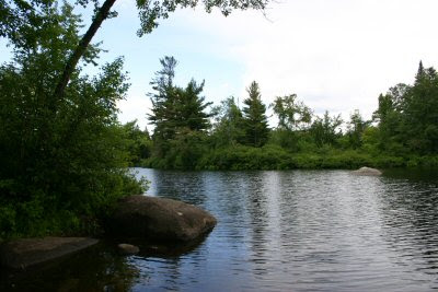
on the Raquette River.
Subscribe to:
Posts (Atom)