Consumer Reports Best Buy Drugs
Dietary Supplements
Green House Long-term Care
Healia Health Search
Healthfinder
Health Grades
Health Insurance site recommended by Newsweek
Health Savings Accounts
Hospital Compare
Mayo Clinic
MedicineNet
Medline
Merck Manual
National Women's Health Info Center
Nursing Homes
Consumer Reports Drugs
Tuesday, August 28, 2007
Sunday, August 26, 2007
Adirondack Links
I have LOTS of links I like to keep track of and many of them I like to share with others. So, instead of having the list of links on the right side of this blog going on and on and on...., I'm trying the approach of creating a blog entry for each category and labeling it appropriately.
Here is the list pertaining to the Adirondacks.
Adirondacks
Adirondack Architectural Heritage
Adirondack Journal
Adirondack Mountain Club
Adirondack Park Invasive Plant Program
Bill Frenette Transitions
Carl Heilman Photography
Fiber Options, Rensselaer Falls
First Night Saranac Lake
Franklin County
Hart House Inn in the 1000 Islands
Hemlock Hall
Lake Placid Center for the Arts
Lake Placid Farmers'Market
Lake Placid Sinfonietta
Morningstar Bistro, Schroon Lake
New York Nature Explorers
Noon Mark Diner
Northern Forest Canoe Trail
Pendragon Theatre
Potsdam Coop
Raquette River Corridor Project
Sagamore
St. Regis Canoe Outfitters
Saranac Lake Winter Carnival
South Meadow Farm Sugarworks
Ten Rivers Recreational Area
Tucker Farms
Tupper Lake
Tupper Lake News
Van Aukens Inne, Old Forge
Wild Center
Wild Center Training
X-Country Skiing
Friday, August 24, 2007
Back to NJ
Yesterday, we drove back to NJ to visit with family before heading for Alaska. Today we drove to Wildwood to spend the day on the beach with AA&J. A good time was had by all.
Monday, August 20, 2007
Kayaking from Middle to Lower Saranac
Today we had a nice one-way paddle from Middle to Lower Saranac with Nancy and Larry. We put in at South Creek where the water was very low, paddled through Middle Saranac Lake, down the river and through the locks into Lower Saranac and out through First and Second Ponds. We stopped and walked around on Bluff Island which is always fun.

Saturday, August 18, 2007
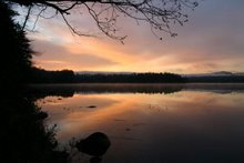
Bear!!
The evidence, as shown in these photos, definitely suggests we have a bear. That post the birdfeeder was on is cast iron. And those holes were made by very large teeth or claws. So the poor birds will have to do without seed for the rest of the year. Has anyone ever heard of a bear-proof bird feeder?

Friday, August 17, 2007
Hike to Moody Falls
Today was one of those spectacular clear days with low humidity that we love here. As part of our ongoing search for the course of the Raquette River, we hiked the short canoe carry from Route 56 to Moody Falls. The carry is quite steep - not one we would attempt with a boat. Plus, it is only .8 miles until you hit Jamestown Falls so hardy worth the paddle. The carry ends downstream of the falls, so we followed a narrow trail along the river to the falls. 

Tuesday, August 14, 2007
Hike to Jamestown Falls
Today we hiked again to Jamestown Falls from the woods road off Route 56. J enjoyed climbing on the rocks and found a green frog in one of the pools.
Monday, August 13, 2007

Sunday, August 12, 2007
Visitors
AA&J arrived Friday. This morning we went dragonfly and damselfly hunting along the edge of the lake. The low water made it easy to explore. We caught then released a Twelve Spotted Skimmer, a male and a female Yellow-legged Meadowhawk, and a Bluet of some sort.
This afternoon we went to the beach at Lake Clear. The "boys" had a great time swimming and playing in the water. What a great spot.
This afternoon we went to the beach at Lake Clear. The "boys" had a great time swimming and playing in the water. What a great spot.
Thursday, August 9, 2007
Kayaking Lower Saranac Lake
Today the weather was very calm so we did a relaxing 6 mile paddle of the eastern end of Lower Saranac Lake. We put in at Ampersand Bay and paddled up Fish Creek until we got to the road at which point it becomes a rocky, shallow, stream. Then we paddled back down the stream and stopped at campsite 34 (marked in red on the map) for a relaxing lunch sitting on a big rock at the water's edge.
Wednesday, August 8, 2007
Kayaking the Raquette River
We have grand plans to eventually kayak all navigable portions of the 170 mile Raquette River that starts in Blue Mountain Lake and ends in the St. Lawrence. Yesterday's paddle got us a bit closer to our goal.
The colors on the following maps are:
Red - parts we have already paddled
Blue - parts yet to paddle
Unmarked sections are not navigable, at least not by our definition.
The following map shows Blue Mountain Lake on the lower right, Raquette Lake on the left and Forked Lake at the top. Sometime soon we'll paddle through Blue Mountain, Eagle, and Utowana Lakes, thus finishing the first section.
 The river goes over Buttermilk Falls as it leaves Forked Lake and then enters the aptly named Long Lake. We'll have to camp overnight in order to do this portion.
 After the river leaves Long Lake it goes over Raquette Falls and then meanders all the way to Tupper Lake.
 We have paddled from Raquette Falls to Tupper Lake and also from Raquette Pond (the north end of Tupper Lake) to Piercefield Dam.
 Earlier this week we paddled from Carry Falls Reservoir to Jamestown Falls. There are many falls and rapids between Piercefield Dam and Jamestown Falls so it is not clear how much of that portion we will be able to paddle, if any.
Some other time I'll describe the rest of the river on its way to the St. Lawrence.
The colors on the following maps are:
Red - parts we have already paddled
Blue - parts yet to paddle
Unmarked sections are not navigable, at least not by our definition.
The following map shows Blue Mountain Lake on the lower right, Raquette Lake on the left and Forked Lake at the top. Sometime soon we'll paddle through Blue Mountain, Eagle, and Utowana Lakes, thus finishing the first section.
The river goes over Buttermilk Falls as it leaves Forked Lake and then enters the aptly named Long Lake. We'll have to camp overnight in order to do this portion.After the river leaves Long Lake it goes over Raquette Falls and then meanders all the way to Tupper Lake.We have paddled from Raquette Falls to Tupper Lake and also from Raquette Pond (the north end of Tupper Lake) to Piercefield Dam.Earlier this week we paddled from Carry Falls Reservoir to Jamestown Falls. There are many falls and rapids between Piercefield Dam and Jamestown Falls so it is not clear how much of that portion we will be able to paddle, if any.Some other time I'll describe the rest of the river on its way to the St. Lawrence.
Tuesday, August 7, 2007
Kayaking the Marion River
Today we paddled 15 miles from the campground on Raquette Lake around Long Point and up the Marion River and back again. The Marion River is actually part of the Raquette River, which doesn't take on that name until it leaves Raquette Lake.
 This is the size of the river near the upstream end.
 We saw this neat church on Long Point. It is reachable only by boat.
 And we saw this strange shrub I had never seen before. It is called the buttonbush (Cephalanthus occidentalis in the Rubiaceae).

We saw the usual great blue herons and think we saw an immature or female eagle as well. We also saw mallards and a merganser.
We saw this neat church on Long Point. It is reachable only by boat.And we saw this strange shrub I had never seen before. It is called the buttonbush (Cephalanthus occidentalis in the Rubiaceae).We saw the usual great blue herons and think we saw an immature or female eagle as well. We also saw mallards and a merganser.
Saturday, August 4, 2007
More on Kayaking the Raquette River
More sights from our paddle today.
 Saw a lot of female mallards resting on a rock.
 Saw beautiful cardinal flowers.
 And also saw our usual great blue herons and a bald eagle.
We investigated a side stream and found a very impressive, two-tiered beaver dam.
Saw a lot of female mallards resting on a rock. Saw beautiful cardinal flowers.And also saw our usual great blue herons and a bald eagle.Kayaking the Raquette River
We had a great explore today. I took so many neat pictures that I'll make two blog entries.
We put the kayak in at the campground on Carry Falls Reservoir (red circle on the map), intending to paddle just to the rapids on the incoming Raquette River and then go back towards the body of the reservoir for more exploring.

 And artsy lines of foam on the water. W says this picture looks like one S would have taken .


We put the kayak in at the campground on Carry Falls Reservoir (red circle on the map), intending to paddle just to the rapids on the incoming Raquette River and then go back towards the body of the reservoir for more exploring.
But we found that initial set of rapids was passable (with a bit of trepidation on my part) so we kept on going all the way to Jamestown Falls. We landed at the spot we'd driven to before (red x on the map) and picked up the trail to the falls and beyond. The trail was wet and rough going a few places but well worth it.
We saw the falls - a big rapid really
And the view downstream from the falls
And artsy lines of foam on the water. W says this picture looks like one S would have taken .More falls upstream of the main ones
And beautiful flat water at the end of the trail.
Friday, August 3, 2007
Kayaking Deer River Flow
Today we kayaked Deer River Flow and up to Horseshoe Pond with a group from ADK. If you head north on Route 30, it is the last significant body of water before you hit the blue line. We put in on Cold Brook Road right off Route 30 and paddled a total of about 9.5 miles. There were beautiful, huge, white water lilies at the entry point. We paddled up to the dam and there were new posted signs all around so we could not land there. But the view back from the dam was very picturesque. I'll have to always take the camera from now on. We lunched at a state forest preserve campsite at the entrance to the creek up to Horseshoe Pond. We saw what was probably a muskrat swimming in the water, several great blue herons, and a huge bald eagle that was sitting in a large white pine next to the water.
We saw what was probably a muskrat swimming in the water, several great blue herons, and a huge bald eagle that was sitting in a large white pine next to the water.
Subscribe to:
Posts (Atom)