We were so pleased when Jim and Cindy invited us to go along on an explore of the newly opened Essex Chain of Lakes. The state recently took over the land and opened it to the public on October 1st. There were already 3 full pages of sign-ins when we got there just 11 days after opening and a ranger we met said there had been a regular parade of folks driving in to paddle.
To get there, drive into Newcomb on 28N and turn right onto Pine Tree Road. Then turn right onto Goodnow Flow Road and follow it down to the flow. Make a right onto Woody's Road and follow the signs to Deer Pond Access. The drive from 28N is about 10 miles. Goodnow Flow Road is paved as is part of Woody's Road but the last several miles of the drive are reminiscent of the rocky road to Lake Lila. I don't recommend doing Lila and the Essex Chain the same week, as we did. It was a bit too much driving on rough roads.
Once you get to the parking lot, you still have 3/4 of a mile to go to get onto Third Lake. The red lines on the following map mark the carries. It is 1/4 mile from the car to Deer Pond, and another 1/2 mile from Deer Pond to Third Lake. Fortunately, most of the carrying is on dirt roads. But the immediate access to the lakes is steep and the put-ins are single file.
After all the work to get there, you'll want to spend the day, and it is definitely worth it.
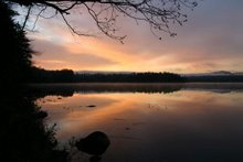
It was cloudy when we started out but as in the last few days, there was absolutely no wind. This was our first view of Third Lake.
We headed up Third Lake and down the creek toward Fourth.
We were surprised to find a nice picnic table for lunch on the northwest shore of Fourth Lake.
Then we proceeded up the lake toward the culvert into Fifth Lake.
Then onto Fifth Lake and the channel into Sixth. The channel is full of mud islands but we managed to maneuver around them. I was so busy navigating I didn't take any photos in the channel.
Then onto Sixth Lake, or is it Seventh? Different maps call it different things. On the map above it is called Sixth.
Then we retraced our route and continued down Third Lake into Second and the end of the line. This impressive 3-4 feet high beaver dam at the end of Second Lake, toward First, is what holds in enough water to allow you to paddle among the lakes. We can't imagine what the area would be like without it.
We didn't have time to walk down to First Lake, though it is possible to carry your boat around and paddle First Lake as well. We'll have to do that next time. Instead, we headed back through Second Lake
and back into Third under blue skies for a total paddling distance of about 8 miles.


No comments:
Post a Comment