 I'm unhappy that all our gentians are gone, along with a lot of dirt. But we fared a lot better than many, so I can't complain. Today we met some of the gang for a paddle on Hoel Pond. We saw several loons and a pair of common mergansers, with the male in full breeding plumage.
On the way home we stopped at the "crusher" to check out the water level. In this photo the river is on the right and the parking lot is on the left.
 Hard to tell which is which. In this shot someone has painted a line on the rock showing the water level on 4/29/11.
  We found some nice blooming dogtooth violets (Erythronium americanum) on the bank there
 and then discovered them at camp as well.
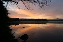
1 comment:
makes me long for August when we will be up there....Lower Saranac..
Post a Comment