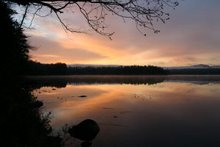
At the moment we are in Green River, Utah, on our first day of our western vacation. This was the view from a rest stop between Grand Junction, CO and Green River.
Friday, September 23, 2011
Toto, I don't think we're in Kansas any more
Or New Jersey, or New York.At the moment we are in Green River, Utah, on our first day of our western vacation. This was the view from a rest stop between Grand Junction, CO and Green River.
At the moment we are in Green River, Utah, on our first day of our western vacation. This was the view from a rest stop between Grand Junction, CO and Green River.

Friday, September 16, 2011
In New Jersey
We drove back to NJ today. Went shopping and to a movie when I got back. Definitely not in the North Country any more.
Monday, September 12, 2011
Irene, Google, and Duck Hole
Friends hiked into what is left of Duck Hole recently, to see what is left after the devastation caused by hurricane Irene, which resulted in the breaching of the dam. What had been a pretty pond, as seen on this satellite view compliments of Google maps, is now a pretty stream winding its way through what had been the lake bed. I've wondered how often Google, or whoever provides their satellite views, overflies an area. Especially an area like the Adirondacks where little supposedly changes from year to year. It will be interesting to see if and when the new view of Duck Hole shows up on the maps. Stay tuned.
is now a pretty stream winding its way through what had been the lake bed. I've wondered how often Google, or whoever provides their satellite views, overflies an area. Especially an area like the Adirondacks where little supposedly changes from year to year. It will be interesting to see if and when the new view of Duck Hole shows up on the maps. Stay tuned.
Paddling Summary 2011
Today was our last paddle of the season, since we leave for NJ on Friday. Here is a summary of the 26 paddles we did this year.
Hoel Pond
Stony Creek Ponds and Ampersand Brook
Weller Pond
Upper Osgood River
Little Tupper Lake
Floodwood/Rollins Loop
North Branch Moose River
Indian Lake
Round Lake
Six Carries
Oswegatchie River
Lower Saranac Lake from Ampersand Bay
Middle Branch St Regis River
Rainbow Lake
Quebec Brook
Taylor Pond
Kunjamuk River
Long Lake
Schroon River
Kushaqua Lake
Ampersand Bay to Lake Flower
Tupper Lake to Bridge Brook Pond
Bog River
South Creek to Second Pond - twice
Raquette Lake to Forked Lake
Hoel Pond
Stony Creek Ponds and Ampersand Brook
Weller Pond
Upper Osgood River
Little Tupper Lake
Floodwood/Rollins Loop
North Branch Moose River
Indian Lake
Round Lake
Six Carries
Oswegatchie River
Lower Saranac Lake from Ampersand Bay
Middle Branch St Regis River
Rainbow Lake
Quebec Brook
Taylor Pond
Kunjamuk River
Long Lake
Schroon River
Kushaqua Lake
Ampersand Bay to Lake Flower
Tupper Lake to Bridge Brook Pond
Bog River
South Creek to Second Pond - twice
Raquette Lake to Forked Lake
Paddling Raquette Lake to Forked Lake
Today the group put in at the town of Raquette Lake and paddled up the lake to the carry into Forked Lake and then paddled to the campground at the east end of Forked Lake, for a total of about 10 miles paddling and 1/2 mile portage. This completes another section in our quest to paddle the navigable portions of the Raquette River.
This completes another section in our quest to paddle the navigable portions of the Raquette River.
Saturday, September 10, 2011
Paddling from South Creek to Second Pond
Today we took Carol and Larry on one of our favorite paddles. They had not realized there were locks nearby and were excited to go through one. It was a beautiful Saturday but since it is after Labor Day we figured there wouldn't be too much traffic. There were a few motor boats, but not enough to spoil the trip. We even got a parking spot at South Creek. We of course had to climb up to the bluff on Bluff Island for lunch and they really enjoyed that too. While I was waiting at Second Pond for W to return with the car, I took this photo looking south from the bridge.
Friday, September 9, 2011
Paddling the Bog River
It was another beautiful day so the two of us put our boats in at Lows Lower Dam and paddled to Hitchins Pond. A lot of other folks had the same idea and there were lots of cars at the put in. We also met many boats on the water. If we go to Lows Lake to camp next year, we'll have to wait a bit later in the season. We initially thought of heading at least partway to Lows Lake, but now that we are paddling tomorrow as well (see the next post), we decided not to go further. We did explore all around Hitchins Pond which we had never done before, for a total paddle of about 8 miles. While we were on shore having our lunch we saw this neat cloud formation over the trees.
Wednesday, August 31, 2011
Paddling Tupper Lake and Bridge Brook Pond
Today just the two of us paddled on Tupper Lake and into Bridge Brook Pond, where we'd never paddled before. We put in at Rock Island Bay (at the lower right on the map) and paddled across the lake to Bridge Brook. Then we portaged our boats into Bridge Brook Pond. This satellite view from google shows how full of vegetation the upper portion of the pond is. So we could not get as far as we had hoped. But it was still a neat explore. The entire trip was about 8.5 miles.
We put in at Rock Island Bay (at the lower right on the map) and paddled across the lake to Bridge Brook. Then we portaged our boats into Bridge Brook Pond. This satellite view from google shows how full of vegetation the upper portion of the pond is. So we could not get as far as we had hoped. But it was still a neat explore. The entire trip was about 8.5 miles.
There were lots of frogs around the pond, including this one that was so big and so still he could have been made of bronze. And I got a good view of a large beaver who slapped his tail and dove when I got near. There were lots of water plants around the edges with these neat fruits, but I don't know what they are.
And I got a good view of a large beaver who slapped his tail and dove when I got near. There were lots of water plants around the edges with these neat fruits, but I don't know what they are.Monday, August 29, 2011
Hurricane Irene
According to a neighbor who checked on it for us, our condo came through the hurricane unscathed. The flooding was not as bad as predicted and there didn't seem to be any leaks. Here in the north country we had lots of rain and wind, but it could have been a lot worse. We haven't been out yet to see if we lost any trees, but since nothing fell on the house, I'm happy.
Friday, August 26, 2011
Paddling from Ampersand Bay to Lake Flower
Twelve of us put in at Ampersand Bay on the east end of Lower Saranac Lake and paddled about 11 miles through First and Second Ponds, through the lower locks on the Saranac River, through Oseetah Lake, and into Lake Flower where we took out at the boat dock. It was a beautiful day.
Subscribe to:
Posts (Atom)