I have finally finished the needlepoint cover for our piano bench. The new colors look much better in the room.
Wednesday, December 18, 2024
Thursday, November 28, 2024
Sunday, November 24, 2024
Longwood Gardens
Clearly, we have been very busy since we arrived back in PA on October 5. Much too busy to post on the blog. But today rates a post since we finally made it to the new, improved Longwood Gardens. The new section opened this week so we really wanted to see it. As members we could have gone before it opened to the public, but we both ended up with Covid when we had planned to go.
We started in the new section, which is fabulous and which had few Christmas decorations. I was looking forward to the Cascade garden, which employed many of the rock arrangements from the original one, but which is now housed in its own building. Lots of water and lots of bromeliads.
The new conservatory has lots of other interesting plants. This photo shows the large palms they managed to get into the building.
I'll share some of the Christmas decorations in the next post.
Tuesday, October 1, 2024
2024 Paddling Summary
Axton to Crusher - twice
Cedar River
Fish Creek
Lake Clear
Little Tupper
Long Pond
Meacham Lake and Lower Osgood
North Branch Saranac River
Piercefield Flow
Rainbow Lake
Rollins Pond
South Creek to Weller
Upper Saranac Lake
Pedaling the Rail Trail
Today we put in at the Floodwood end and rode 3 miles to the other side of Hoel Pond, almost to the spot we stopped at coming from the other end the last time we were on the trail. Then we turned around for a total of 6 miles, which is enough until we buy some nice, padded biking shorts. Sure wish we had remembered that they existed. We will buy some and be ready for next year's rides.
Sunday, September 29, 2024
Paddling Upper Saranac Lake
Today was our last paddle of the season. It was another beautiful calm day so when friends invited us to paddle around the southern end of Upper Saranac Lake, we said yes, even though it is a Sunday. That didn't turn out to be a problem at all - there were few boats on the lake and none close to us. We put in at the Indian Carry launch and paddled 6.25 miles, stopping briefly at the Bartlett Carry to stretch our legs.
The dam is apparently under repair.
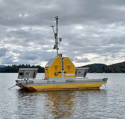
This is a weather station associated with Paul Smiths that is moored out in the middle of the lake.
Sunday, September 22, 2024
Paddling Fish Creek
We had another great paddle today. We put into the southern end of Fish Creek, in the Fish Creek Campground, and paddled upstream. We went into Copperas Pond where we hadn't been in years and paddled across to the carry to Whey Pond. We were curious to see whether the carry was wheel-able so we walked the length of it - 0.3 miles in each direction. We decided it is doable though there are quite a few roots to get over. This is the view of Copperas from the carry
and this is Whey.
There were lots of neat mushrooms along the trail.
Then we paddled back to the creek and went all the way into Floodwood, stopping for lunch at our favorite spot along the way. Then back the way we came for a total of 6 miles of paddling plus the 0.6 miles of walking. It was a gorgeous day.
Wednesday, September 18, 2024
Biking the Rail Trail
We had a wonderful ride on the rail trail today. We parked at the end of Station Rd by the fish hatchery. There were no other cars there when we arrived. We rode 3.25 miles toward Floodwood Rd, turning around a bit past the home of some friends on Hoel Pond, for a total of 6.5 miles. This is a view of Rat Pond as you ride by.
When we got back to the parking lot, which had quite a few cars in it by then, we noticed this wonderful mushroom. Another biker said it was called a Shaggy Mane.
Sunday, September 15, 2024
Paddling Rollins Pond
It was another gorgeous day with little wind. And Rollins Pond was the perfect place to paddle on a Sunday since the campground closed right after Labor Day. We paddled around the lake for a total of 5 miles.
We climbed up to the rail trail to check the progress and discovered that nothing has been done on this section yet.
Thursday, September 12, 2024
Paddling Little Tupper Lake
We had a wonderful 8 mile paddle on Little Tupper Lake today. When we started out there was no wind. The water was like glass.
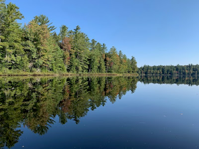
The reflections were so great it was like paddling through the clouds.
We paddled up the stream that flows in from the north until we were stopped by a big beaver dam. We might have found a way over it, but the lake was so inviting we decided to retreat.
We stopped for lunch on one of the beaches where there were moose tracks, which was very neat.
While we were stopped it rained a bit but not enough to spoil the fun.
Thursday, September 5, 2024
Paddling Rainbow Lake
We put in at the usual spot on Clark Wardner Rd and did the 7 mile paddle to the other end at Kushaqua-Mud Pond Rd where cars were waiting. It was a beautiful day.
We paddled up the northwestern end until we were stopped by a beaver dam and knew we couldn't go much further even if we climbed over it.
We stopped at a nice spot for lunch with this great view.
Tuesday, September 3, 2024
Biking the Rail Trail
Today we finally made it to the rail trail. We combined the trip with picking up veggies, so we just started where Rt 86 crosses the trail outside of Saranac Lake, and headed toward Ray Brook. We only went a bit under 6 miles round trip, but that was fine for the first time on bikes for quite a while. There was a section that went slightly uphill, so it was good to be starting out that direction.
Monday, August 26, 2024
Paddling Lake Clear
We paddled on Lake Clear today. We put in on Lake Clear Outlet off Forest Home Road. We paddled around the west and north shores and ended at the beach for lunch. The total distance was 4.75 miles. There was little wind and it was cloudy and hazy most of the time. This is a view in the outlet.
Tuesday, August 20, 2024
Paddling the Cedar River
Eight of us put in to Cedar River Flow and paddled up the river a bit. Some of the group had been there recently so, unlike other years, we did not spend a lot of time looking for the correct route. At first we weren't even sure we were going to paddle. It rained off and on for most of the 1 1/2 drive to get there. It wasn't raining when we all had the boats ready to go but then it started sprinkling. High winds were also forecast, but we decided to paddle for a bit anyway since we were there. It did not rain most of the time, but we got sprinkled on a bit, and much more as we were coming back. The wind was behind us going upstream and wasn't as bad as we expected when we paddled back to the cars. The photo shows what the weather looked like. And it was cold as well.
Thursday, August 8, 2024
Paddling Meacham Lake and the Lower Osgood River
I wasn't able to go on this paddle due to bursitis in my hip which makes sitting for a long time very painful. But W went on the paddle and I wanted to document it. Unfortunately, he lost his phone on the trip so I don't have pictures.
The group put in at the usual spot at the dam for the East Branch of the Saint Regis River and paddled to the outlet for the Lower Osgood. We had been told there were beaver dams obstructing the river, but that was not the case. The only obstacle was a couple of trees down which some the of group climbed over and some carried around. The river was great and they only turned around because it was time to go back to the beach on the southern shore of the lake for lunch. Because it was a slow trip, they didn't get very far.
Tuesday, July 30, 2024
Paddling Long Pond
We did another paddle today. It is unusual for us to do two paddles in a row and we are very tired, especially because it was in the 80's both days.
This paddle was 6.5 miles on Long Pond with our usual group. This time we used wheels on both boats to do the carry and that worked well. On the return trip we carried the boats up the steep and rocky trail at the beginning then used the wheels the rest of the way.
We stopped for lunch at the carry to Slang Pond because there is a nice beach there and some folks wanted to swim.
Monday, July 29, 2024
Paddling from Axton to Crusher Again
We paddled the 7 miles from Axton to the Crusher today because our friends wanted to do that paddle. We had tried to paddle with them on Taylor Pond yesterday, but it was too windy. Then we went to the brewery for a late lunch. It was a nice visit.
Wednesday, July 24, 2024
Photos Around Camp
I finally got around to taking some photos in our woods. These are some of my favorites.
Slime mold?
Neat small moss and ferns
Lycopodium
Lichen and moss
Jack-in-the-pulpit fruit


